Memorandum of Understanding Tribal Information

| Contact Information: | Coeur d'Alene Tribe Headquarters, PO Box 408, 850A Street, Plummer ID 83851, Phone: 208-686-1800 |
| State Legislative District: | Idaho State Legislative Districts 3 and 5 |
| Congressional District: | Idaho Congressional District 1 |
| Counties: | Kootenai County, Benewah County |
| Reservation Description: | The Coeur d'Alene Indian Reservation is located in north-central Idaho with tribal headquarters located in the town of Plummer. The reservation consists of 345,000 acres. The lower one-third of Lake Coeur d'Alene is on the reservation. The reservation is primarily of fringe ecosystem where the Palouse prairie meets the forests of the western slopes of the Bitterroot Mountains. Historically, the Coeur d’Alene people lived on 5,000,000 acres in eastern Washington, as far north as Lake Pend Oreille and south to the north shores of the Snake River in Idaho. The valleys and mountains of Western Montana were included as the homelands. |
| Population/Enrollment: | The people's name for themselves is Schitsu'umsh, "Those Found Here" or "Discovered People." There are 2,405 enrolled members of the tribe. |
| Enterprises: | Coeur d'Alene Casino/Hotel, Circling Raven golf Course, Development Corp, Benewah market, Benewah Ace Hardware, Benewah Automobile, Tribal Farm, Echelon (Formerly Berg), Conoco Station, Red Spectrum Communications |
| Schools(Public/Tribal): | Coeur d'Alene Early Childhood Learning Center, Phone: 208-686-6507 Plummer-Worely School District #44, P.O. Box 130, Plummer, Idaho 83851 Phone: 208-686-1621 Lakeside Elementary Phone: 208-686-1651 Lakeside Jr/Sr High School Phone: 208-686-1627 Coeur d'Alene Tribal School, Grades P-8, 30 Moctelme Street / P.O. Box 338, Desmet, Idaho 83824, Phone: 208-686-5808, funded by the Bureau of Indian Affairs. |
| Reservation Map: | 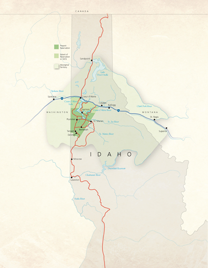 |
| Contact Information: | The Yakama Nation Main Agency Offices, 401 Fort Road, P.O. Box 151, Toppenish, WA 98948, Phone: 509-865-5121 |
| State Legislative District: | Washington State Legislative District 14 and 15 |
| Congressional District: | Washington State Congressional District 4 |
| Counties: | Yakima County |
| Reservation Description: | The Yakama Nation is comprised of 1,130,000 acres. The western boundary includes the eastern half of 12,307 foot high, Pahto, also known as Mount Adams. The northern boundary drops off of the crests of the Cascade Mountains, down onto and following Ahtanum Ridge eastward to where the Yakima River becomes the eastern boundary. Toppenish Ridge encloses the reservation as its southern border. The eastern portion of the Yakama Nation contains approximately 600,000 acres of forest. The lower, eastern basin is under the rain shadow of the Cascades, a dry landscape of sagebrush steppe, irrigated by mountain runoff. |
| Population/Enrollment: | The Confederated Tribes and Bands of the Yakama Nation consists of 10,200 (2011) enrolled tribal members. In 1855, tribal peoples of the Columbia Plateau signed a treaty with the United States, including those who were to become known as the Yakama Nation. The people who became tribal members are originally the Li-ay-was, Kow-was-say-ee, Kah-milt-pah, Oche-chotes, Klickitat, Se-ap-cat, Klinquit, Shyiks, Palouse, Wenatshapam, Yakama, Skinpah, Pisquose and Wishram peoples. |
| Enterprises: | Yakama Nation Forest Products, Yakama Nation Legends Casino, Yakama Nation Cultural Center, Yakama Nation Resort RV Park, Yakama Nation Land Enterprise, Yakama Nation Wildlife, Yakama Nation Gaming Commission, Yakama Power, Yakama Nation Fruit and Produce, Yakama Nation Networks |
| Schools(Public/Tribal): | Toppenish School District, 306 Bolin Dr. Toppenish, WA 98948 Phone: 509-865-4455 Granger School District # 204, 701 E AVE, Granger WA 98932 Phone: 509-854-1515 Wapato School District, 212 West Third Street, Wapato WA 98951 Phone: 509-877-4181 Yakama Nation Tribal School, 601 Linden Street, Toppenish WA 98948 Phone: 509-865-4778 Klickitat School District # 402, PO Box 37 / 98 School Drive, Klickitat WA 98628 Phone: 509-369-3422 Lyle School District # 406, 625 Keasey Avenue, Lyle WA 98635 509-767-1132 Glenwood School District # 401, 320 Bunnell Street, Glenwood WA 98619 Phone: 509-364-3438 Wishram School District # 94, 135 Bunn Rd. / PO Box 8, Wishram WA 98673 Phone: 509-748-2127 Mount Adams School District, 621 Signal Peak Rd. White Swan, WA 98952 Phone: 509-874-2611 Ellensburg School District, 1300 E Third Avenue, Ellensburg WA 989226 Phone: 509-925-8010 Zillah School Disrict, 213 Fourth AVE, Zillah WA 98953 Phone: 509-829-6290 Goldendale School District, 604 Brooks St., Goldendale WA 98620 Phone: 509-773-5177 Wahluke School District, 411 East Saddle Mountain Drive, / PO Box 907, Mattawa WA 99349 Phone: 509-932-4565 Yakima School District, 104 N 4th Avenue, Yakima WA 98902 Phone: 509-573-7300. |
| Reservation Map: | 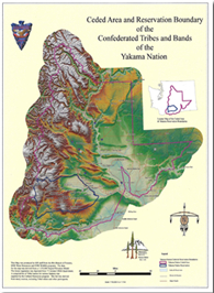 |
| Yakama Nation Tribal Council: Chairman: JoDe L. Goudy Vice-Chairwoman: Delano Saluskin Secretary: Athena Sanchey-Yallup Assistant Secretary: Gerald Lewis Sargent at Arms: Ash Washines Council Member: Asa Washines Council Member: Delano Saluskin Council Member: Frank Mesplie Council Member: Raymond Smartlowit Council Member: Richard George Council Member: Ruth Jim Council Member: Sam Jim Sr. Council Member: Virgil Lewis Council Member: Vivian Babs George |
| Contact Information: | Colville Tribes, P.O. Box 150, Nespelem, WA 99155; Phone: 509-634-2238; Fax: 509-634-2276 |
| State Legislative District: | Washington Legislative Districts 7 and 12 |
| Congressional District: | Washington Congressional District 5 |
| Counties: | Southeastern section of Okanogan County and the southern half of Ferry County, other pieces of Trust lands are located in Chelan County. |
| Reservation Description: | The Colville Reservation is located in north-central Washington State, consisting of 11.4 million acres and is bordered on the west by the Okanogan River and to the south and west by Lake Roosevelt and the Columbia River. The northern boundary runs in a straight line from north of Omak and ends north of the community of Inchelium. There are small parcels of trust lands located in Chelan County. The reservation is located on the Okanogan Highlands with elevations ranging from 790 feet to 6,774 feet at the summit of Mount Moses. |
| Population/Enrollment: | There are approximately 9,486 enrolled tribal members who are descendants of 12 tribes and bands: Colville, Nespelem, San Poil, The Lake, Palus, Wenatchi, Chelan, Entiat, Methow, Okanogan, Moses Columbia and Nez Perce of Chief Joseph's Band. About 60% of those members reside on the Colville reservation. |
| Enterprises: | The Colville Tribal Federal Corporation employs 800 people and generates $120 million in revenue by managing 13 enterprises that include recreation, gaming, tourism, construction, wood products and retail. |
| Schools(Public/Tribal): | Higher Education Office Phone: 509-634-2779 Inchelium Headstart Phone: 509-722-7054 Keller Headstart Phone: 509-634-7316 Nespelem Headstart Phone: 509-634-2298 Omak Headstart Phone: 509-422-7708 Inchelium School District # 70, Grades P-12, P.O. Box 285, Inchelium, Washington 99138 Phone: 509-722-6181 Columbia School District# 206, Grades P-12, P.O. Box 7 4961B Hunters Shop Road, Hunters, Washington 99137 Phone: 509-722-3311 Keller School District # 3, Grades K-6, P.O. Box 367 17 South School Road, Keller, Washington 99140 Phone: 509-634-4325 Republic School District # 309, Grades K-12, 30306 E Highway 20, Republic, Washington 99166-8746 Phone: 509-775-3173 Wilbur School District # 200, Grades K-12,SE 202 Pope St., Wilbur, Washington 99185 Phone: 509-215-0184 Nespelem School District # 014, Grades P-8, 229 School Loop Road P.O. Box 291, Nespelem, Washington 99155-1291 Phone: 509-634-4541 Grand Coulee Dam School District, Grades K-12, 110 Stevens Avenue Coulee Dam, Washington 99116 Phone: 509-633-2143 Pascal Sherman Indian School, Grades K-9, 169 North End Omak Lake Road, Omak, Washington 98841 Phone: 509-422-7590, funded by Bureau of Indian Affairs Omak School District # 19, Grades K-12, 619 W. Bartlett Ave. / P.O. Box 833 Omak, Washington 98841 Phone: 509-826-0320 Okanogan School District, Grades K-12, 115 Rose Street / P.O. Box 592, Okanogan, Washington 98840 Phone: 509-422-3629 |
| Reservation Map: | 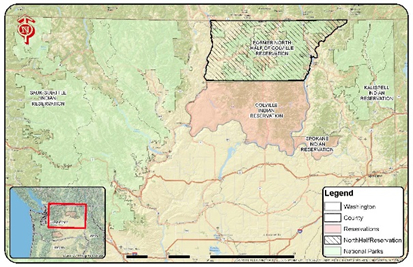 |
| Contact Information: | Nixy'aawii Governance Center, 46411 Timine Way, Pendleton, Oregon 97801. Communications Department, Phone: 541-429-7010, Email: communications@ctuir.org Website: Umatilla Indian Reservation/td> |
| State Legislative District: | Oregon State House Districts 57, 58. Oregon State Senate District 29 |
| Congressional District: | Oregon Congressional District 2 |
| Counties: | Umatilla County |
| Reservation Description: | The Confederated Tribes of the Umatilla Indian Reservation is home to the Walla Walla, Umatilla and Cayuse peoples. The reservation consists of 172,882 acres of which 52 percent is owned by tribal members and 48% is non-Indian owned. The reservation is adjacent to the towns of Pendleton, Adams, Weston, and Pilot Rock, Oregon, and includes the bottom lands, foothills and higher forests of the Blue Mountains. |
| Population/Enrollment: | 2,965 tribal members with approximately half these tribal members living on or near the Umatilla reservation. About 300 Indians of other tribes also call the Umatilla reservation home. About 1,500 non-Indians reside on the reservation as well. |
| Enterprises: | Wildhorse Casino, Arrowhead Travel Plaza, Ataw Consulting, LLC, Business Development Services, Cayuse Technologies, Coyote Business Park, CTUIR Tribal Native Plant Nursery, Indian Lake, Mission Market, Tama'stslikt Cultural Institute, Yaka Energy |
| Schools(Public/Tribal): | Cay-Uma-Wa Head Start Program, Mission, Oregon Nixya'awii High School, 73300 July Grounds Lane, Pendleton Oregon 97801 Phone: 541-966-2680 Pendleton School District, 1100 Southgate, Suite B, Pendleton, Oregon 97801 Phone: 541-276-6711 Athena Weston-School District #29RJ, 375 S. 5th Street, Athena, Oregon 97813 Phone: 541-566-3551 Pilot Rock School District , 200 McGowan Drive, P.O. Box BB, Pilot Rock, Oregon 97868 Phone: 541-443-8291 |
| Reservation Map: | 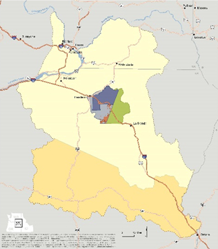 |
| Contact Information: | Confederated Tribes of the Warm Springs Reservation, Main Agency Offices, 1233 Veterans Street, P.O. Box C, Warm Springs, OR 97761, Phone: 541-553-1161 |
| State Legislative District: | Oregon State House District 59, Oregon State Senate District 30 |
| Congressional District: | Oregon State Congressional District 2 |
| Counties: | Jefferson County |
| Reservation Description: | The reservation that the Tribes control has a land area of 1,000 square miles. |
| Population/Enrollment: | The Confederated Tribes of the Warm Springs Reservation has 4,800 enrolled tribal members, of which 3,700 live on the reservation (2008). The Tribes are governed by an 11 member Tribal Council, of which three serve life positions on council as Chiefs of the three Tribes that conduct their affairs through a constitutional government since 1938. Eight Tribal Council Members are elected per district and serve for three years. |
| Enterprises: | Warm Springs Ventures, Warm Springs FAA UAS Test Range, Construction Enterprise, Warm Springs Credit Enterprise, Warm Springs Cannabis, Warm Springs Geo Visions, High Lookee Lodge, Indian Head Casino, Kah-Nee-Ta Resort and Spa, The Museum at Warm Springs, Warm Composite Products, Warm Springs Power and Water Enterprises, Warm Springs Telecom |
| Schools(Public/Tribal): | Warms Springs K-8 Academy, 50 Chukar Rd, Warm Springs, OR 97761, Phone: 541-553-1128 Madras High School, 390 SE 10th St, Madras, OR 97741, Phone: 541-475-7265 |
| Reservation Map: | 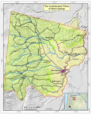 |
| Contact Information: | Kalispel Tribal Headquarters, P.O. 39 Usk, Washington 99180, Phone: 509-445-1147, Fax: 509-445-1705 |
| State Legislative District: | Washington Legislative District 7 |
| Congressional District: | Washington Congressional District 5 |
| Counties: | Pend Oreille County, Spokane County |
| Reservation Description: | The Kalispel reservation was established in 1914 and consisted of seven-square miles on the eastern bank of the Pend Oreille River near the towns of Usk and Cusick, Washington. Since that time four-square miles have been added including a half square mile within the city of Airway Heights, Washington. The Kalispel Tribe holds an additional five-and-one-half-square miles of forest and natural resource property in northeast Washington and north Idaho. The main reservation is made up of 4,654 acres. Originally, Lake Pend'Orieille, Priest Lake and the plains of northwestern Montana are made up the Kalispel homeland. |
| Population/Enrollment: | The Kalispel Tribe currently consists of 450 members with approximately one-third residing on the reservation. Many tribal members reside on the neighboring county of Spokane and throughout Pend Oreille County. The tribal members are of the Lower Kalispels. The Upper Kalispel tribesmen now reside on the Confederated Salish and Kootenai Reservation in Montana, where they are known as the Pend'Orieille and on the Confederated Tribes of the Colville Reservation in north central Washington. |
| Enterprises: | Northern Quest Casino, Kaltran - Tribal Transit, Camas Center for Community Wellness, Kalispel Kafe, Kalispel Agricultural Enterprise |
| Schools(Public/Tribal): | Kalispel Tribe Director of Education Phone: 509-447-7141 Kalispel Tribe Higher Education Office Phone: 509-445-0272 Cusick School District # 59, 305 Monumental Way, Cusick, Washington 99119 Phone: 509-445-1125 Kalispel Career Training Center, Cusick Washington, provides vocational training to tribal and non-tribal members Camas Learning Center, 109 First Street, Cusick, Washington 99119 Phone: 509-447-7140, provides tutoring to tribal and non-tribal youth of Cusick School Districts and provides education in the Kalispel language and Kalispel tribal culture. |
| Reservation Map: | 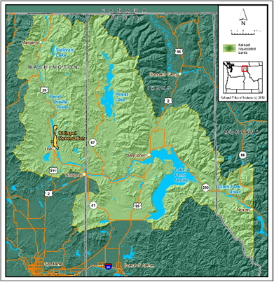 |
| Contact Information: | Kootenai Tribe of Idaho, P.O. Box 1269, Bonners Ferry, Idaho 83805, Phone: 208-267-3519, Fax: 208-267-2960 |
| State Legislative District: | Idaho Legislative District 1 |
| Congressional District: | Idaho Congressional District 1 |
| Counties: | Boundary County |
| Reservation Description: | The Kootenai Indian Reservation was first established in 1896, and after severe land loss, 12.5 acres was deeded by Executive Order after the Kootenai people declared war on the United States on September 20, 1974. Currently, the Kootenai Tribe of Idaho has land holdings consisting of 3,985 acres in-and around Bonners Ferry, Idaho. |
| Population/Enrollment: | The Kootenai Tribe of Idaho has 252 enrolled members with approximately 75 to 80 members residing on the reservation. The Kootenai Tribe of Idaho is one of seven bands of Kootenai including: Lower Kootenai Band in Creston, BC, St Mary's Band of Cranbrook, BC, Columbia Lake Band in Windemere, BC, Shushwap Band, in Invermere, BC, Tobacco Plains Band in Grasmere, BC, and the Confederated Salish and Kootenai Tribe in Elmo, Montana. |
| Enterprises: | Kootenai River Inn Casino and Spa, Twin Rivers Canyon Resort and Burbot Hatchery |
| Schools(Public/Tribal): | Boundary County School District 101, 7188 Oak Street, Bonners Ferry, Idaho 83805 Phone: 208-267-7217 Bonners Ferry High School Phone: 208-267-3149 Boundary County Middle School Phone: 208-267-3146 Naples Elementary School Phone: 208-267-2965 Mount Hall Elementary School Phone: 208-267-5276 Valley View Elementary School Phone: 208-267-5519 |
| Reservation Map: | 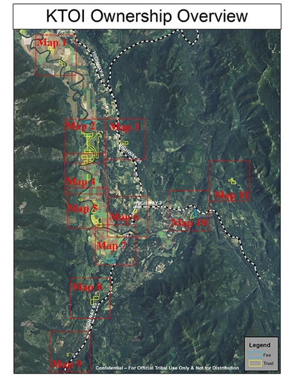 |
| Contact Information: | The Nez Perce Tribe, P.O. Box 305, Lapwai, Idaho 83540, Phone: 208-843-2253 Fax: 208-843-7354 |
| State Legislative District: | Idaho State Legislative Districts 6 and 7 |
| Congressional District: | Idaho Congressional District 1 |
| Counties: | Nez Perce County, Lewis County, Clearwater County, Idaho County |
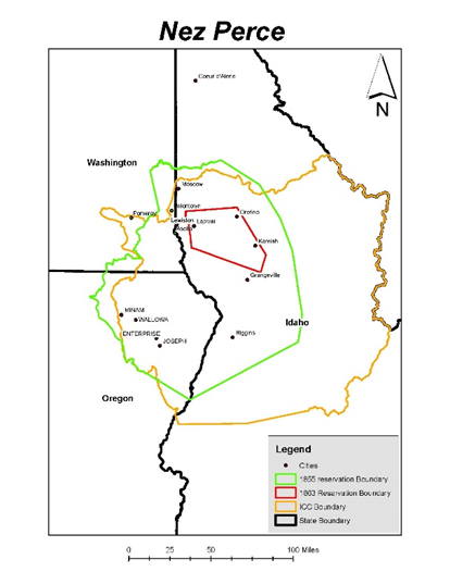
| Reservation Description: | The Nez Perce Indian Reservation is located between the lower Clearwater and Salmon river drainages in north central Idaho. The reservation is comprised of 770,453 acres of which 385,227 acres is considered cropland, 261,954 acres of grazing land and 100,159 acres is forestland. Of this acreage, the Nez Perce Tribe and Nez Perce tribal members own approximately 13%. Traditional Nez Perce territory consisted of over 17 million acres and covered northeast Oregon, Southeastern Washington, north central Idaho, and the buffalo country of Montana and Wyoming. |
| Population/Enrollment: | Nez Perce Tribal enrolled members number 3,542 (2014) with approximately 2,000 tribal members residing on the reservation. The total population of the Nez Perce reservation is 18,437. The Nimi'ipuu (Nez Perce) people originate from two bands, the lower Nimi'ipuu of the Wallowa, Oregon Valley and the Upper Nimi'ipuu of the Clearwater River and lower Salmon River mountains and valleys. |
| Enterprises: | Clearwater River Casino/Hotel, IT'SeYeYe Casino, Nez Perce Express Store, Camas Express Store, Aht'wy Plaza RV Park, Nez Perce Forest Products |
| Schools(Public/Tribal): | Nez Perce Tribe Early Childhood Development Program: Lapwai, Idaho, Phone: 208-843-7330, Kamiah, Idaho, 208-935-2888 Lewis-Clark Early Childhood Program, Kamiah, Phone: 208-935-2811 Lapwai School District # 341, 404 Main Street, P.O. Box 247, Lapwai Idaho 83540 Phone: 208-843-2622 Lapwai Elementary Phone: 208-843-2952 Lapwai High School Phone: 208-843-2241 Culdesac Joint School District # 342, 600 Culdesac Avenue, Culdesac, Idaho 83524 Phone: 208-843-5413 Highland Joint School District # 305, 112 Boulevard Avenue, P.O. Box 130, Craigmont, Idaho 83523 Phone: 208-924-5211 Nezperce School District # 302, P.O. Box 279, 614 2nd Avenue, Nezperce, Idaho 83543 Phone: 208-937-2551 Orofino Joint School District # 171, 1051 Michigan Avenue, Orofino, Idaho 83544 Phone: 208-476-5593 Cavendish-Teaken Elementary (Lenore) Phone: 208-476-5393 Peck Elementary Phone: 208-486-7331 Orofino Elementary Phone: 208-476-4212 Orofino Jr. High School Phone: 208-476-5557 Timberline Schools, P-12 , Weippe, Idaho Phone: 208-435-4411 |
| Reservation Map: |
|
| References: | UI Extension, Nez Perce County |
| Contact Information: | Shoshone-Bannock Tribes Headquarters, P.O. Box 306, Fort Hall, Idaho 83203, Phone: 208-478-3700 |
| State Legislative District: | Idaho State Legislative Districts 28, 29, 31 |
| Congressional District: | Idaho Congressional District 2 |
| Counties: | Bannock County, Bingham County, Caribou County, Power County |
| Reservation Description: | The Shoshone-Bannock people reside on the Fort Hall Indian Reservation of southeast Idaho. The reservation spans 540,764 acres and is 97% Indian owned. The reservation is divided into five tribal legislative districts: Fort Hall, Ross Fork, Gibson, Bannock Creek, and Lincoln. The Fort Hall reservation was established July 2, 1863, by the Treaty of Fort Bridger. The original reservation land base of 1.8 million acres was ceded two times to its present size. |
| Population/Enrollment: | The Shoshone-Bannock Tribes have 5,854 enrolled members with 4,038 members residing on the Fort Hall Indian Reservation. There are 1,826 non-Indians living on the Fort Hall reservation. The Fort Hall Shoshone are descended from the Lemhi, Bruneau, Weiser, Sheep Eater, Boise Valley, and Wind River Shoshone. The Bannock, as well as the Shoshone, have relations throughout the state of Nevada, Utah, and Warm Springs, Oregon. |
| Enterprises: | Shoshone-Bannock Enterprises, Phone: 208-235-2022; Bannock Peak Casino, Buffalo Enterprise, Bannock Peak Truck Stop, Clothes Horse, Smoke House, T.P. Gas Station, Trading Post Grocery |
| Schools(Public/Tribal): | Shoshone-Bannock Early Childhood Headstart, Fort Hall, Idaho, Phone: 208-239-4500 Chief Tahgee School District # 483, Chief Tahgee Elementary Academy, P.O. Box 217 - 38 S Highline Rd Fort Hall ID 83203, Phone: 208-237-2710, Fax: 208-237-1734 Shoshone-Bannock School District #512 or 537: P.O. Box 790 , Fort Hall, Idaho 83203 Phone: 208-238-4200 Shoshone-Bannock Junior / Senior High School, 17400 Hiline Rd, Pocatello, Idaho 83202 Phone: 208-238-4200 Blackfoot School District # 55: Vaughn Hughie Early Childhood Center, 420 Center St Blackfoot, ID 83221 Phone: 208-785-8848 Irving Kindergarten Center, 440 W Judicial Blackfoot ID 83221, Phone: 208-785-8835 Fort Hall Elementary, RT 6 Box 430, Ft Hall, ID 83202, Phone: 208-237-2207 Groveland Elementary, 375 W 170 N Blackfoot, ID 83221, 208-785-8829 Ridge Crest Elementary, 800 Airport Rd Blackfoot ID 83221, 208-785-8894 Donald D. Stalker Elementary, 991 W Center Blackfoot ID 83221, Phone: 208-785-8841 I.T. Stoddard Elementary, 460 York Drive Blackfoot ID 83221, Phone: 208-7850-8832 Wapello Elementary, 195 E 350 N Blackfoot ID 83221, Phone: 208-785-8844 Blackfoot Sixth Grade School, 50 S Shilling Blackfoot ID 83221, Phone: 208-785-8838 Mountain View Middle School, 645 Mitchell Ln Blackfoot ID 83221, Phone: 208-785-8820 Summit Middle School, 270 E Bridge St Blackfoot ID 83221, Phone: 208-785-8800 Blackfoot High School, 870 S Fisher Blackfoot ID 83221, Phone: 208-785-8810 Independence High School, 155 E Francis Blackfoot ID 83221, Phone: 208-785-8825 Pocatello/Chubbuck School District No. 25, 3115 Poleline Rd Pocatello ID 83201, Phone: 208-232-3563 Chubbuck Elementary, 600 W Chastain, Phone: 208-237-2272 Edahow Elementary, 2020 Pocatello Cr Rd, Phone: 208-233-1844 Ellis Elementary, 5500 Whitaker Rd, 208-237-4742; Gate City Elementary, 228 Hiskey, Phone: 208-237-2503 Green acres Elementary, 1250 Oak, Phone: 208-233-2575 Indian Hills Elementary, 666 Cheyenne, Phone: 208-232-4086 Jefferson Elementary, 1455 Gwen, Phone: 208-232-2914 Lewis and Clark Elementary, 880 Grace Drive, Phone: 208-233-2552 Lincoln Center/Early Intervention, 330 Oakwood Drive, Phone: 208-232-2994 Montessori Elementary, 12743 Tyhee Rd, Phone: 208-237-0551 Syringa Elementary, 388 E Griffeth Rd, Phone: 208-237-4040 Tendoy Elementary, 957 E Alameda, Phone: 208-233-2921 Tyhee Elementary, 12743 W Tyhee Rd, Phone: 208-237-0051 Washington Elementary, 226 S 10th Ave, Phone: 208-232-2976 Wilcox Elementary, 427 Lark Lane, Phone: 208-237-6050 Alameda Middle School, 845 McKinley, Phone: 208-235-6800 Century High School, 7801 Diamondback Drive, Phone: 208-478-6863 Franklin Middle School, 2271 E Terry, Phone: 208-233-5590 Hawthorne Middle School, 1025 W Eldridge, Phone: 208-237-1680 Highland High School, 1800 Bench Rd, Phone: 208-237-1300 Irving Middle School, 911 N Grant, Phone: 208-232-3039 New Horizons (Alternative) , 955 W Alameda Rd, Phone: 208-237-2233 Pocatello High School, 325 N Arthur, Phone: 208-233-2056 |
| Reservation Map: | 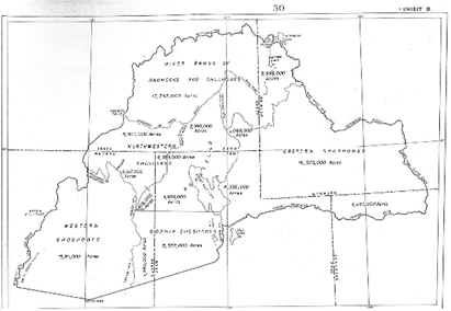 |
| References: | Shoshone Bannock Fort Hall Reservation |
| Contact Information: | Shoshone-Paiute Tribal Headquarters ,1008 Idaho State Highway 51, Owyhee County, Idaho 83604; Tribal Headquarters, P.O. Box 219, Owyhee, Nevada 89832; Phone: 208-759-3100 Fax: 208-3103 Email: council@shopai.org |
| State Legislative District: | Idaho State Legislative District 23 Nevada State Legislative Rural District 8 |
| Congressional District: | Idaho Congressional District 1 Nevada Congressional District 2 |
| Counties: | Owyhee County, Idaho Elko County, Nevada |
| Reservation Description: | The Shoshone-Paiute Reservation, also known as the Duck Valley Indian Reservation, consists of 280,071 acres and is located on the southern boundary of Idaho and the northern state line of Nevada. The East Fork of the Owyhee River flows through the reservation providing irrigated water through the Wildhorse Reservoir to 12,800 acres of tribal farmland. Sheep Creek, Mountain View and Billy Shaw Reservoirs, supplied by snow melt are on the Shoshone-Paiute lands. Approximately 80% of tribal members utilize reservation lands for farming and ranching. The central community is Owyhee, 97 miles south of Mountain Home, Idaho, and 98 miles north of Elko, Nevada. |
| Population/Enrollment: | Tribal enrollment is 2,132 with approximately 1,200 tribal members living on the reservation. Enrolled members are descendants of the Western Shoshone and Northern Paiute, who once lived in Oregon and all of southern Idaho and northern Nevada. Blood relatives of the Shoshone-Paiute include members of the Warm Springs Tribes of Oregon, the Shoshone-Bannock Tribes of southeastern Idaho, the Wind River, Wyoming, Shoshones and the scattered Shoshone-Paiute Colonies throughout Nevada. |
| Enterprises: | Our Grocery Store, Economic Development Corporation, Ace Hardware Store, Treasure Valley Development Corporation, Shoshone-Paiute Tribes 101 Ranch |
| Schools(Public/Tribal): | Owyhee Combined School, Elko County School District, 100 Academic Way, Owyhee, Nevada 89832 Phone: 775-757-3400 |
| Reservation Map: | 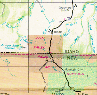 |
| Contact Information: | Spokane Tribe of Indians, 6195 Ford-Wellpinit Road, P.O. Box 100, Wellpinit, Washington 99040 Phone: 509-458-6500 |
| State Legislative District: | Washington State Legislative District 7 |
| Congressional District: | Washington Congressional District 5 |
| Counties: | Stevens County |
| Reservation Description: | The Spokane Tribe's reservation is bounded by the Columbia River to the east, the Spokane River to the south, Tshimokiane Creek to the east and the northern boundary is approximately 1/4 mile north of the 48th Parallel. The Spokane reservation consists of close to 159,000 aces of which 108,874 acres is forest land, 8,552 acres of agricultural land, 10,328 acres of lakes and 145 acres of Trust land in Spokane County adjacent to the community of Airway Heights. The reservation was created in January 1881, by Executive Order, reducing Spokane ancestral lands of what was once three-million acres. |
| Population/Enrollment: | The Spokane Tribe has 2,849 enrolled members with 1,228 members residing on the reservation. The Spokane people, formerly composed of three bands: The Lower, Middle and Upper; made their living from fishing, hunting and gathering. After the loss of tribal lands and the designation of the small, present day Spokane reservation, the three bands of Spokanes’ were split. Displaced Spokanes’ found homes on the Coeur d'Alene, Colville and Montana Flathead reservations, where their descendants reside today. |
| Enterprises: | Spokane Casinos and Resorts: Chewelah Casino, Two Rivers Casino, Two Rivers Resort (Marina and Campground); Spoko Fuel Stations: Chewelah, Two Rivers, Marina, Wellpinit, West Plains; Food Services: Airway Heights Arby's, Chewelah Chester Chicken, Two Rivers Spoko Deli, Wellpinit Trading Post Deli; Other Enterprises: Spokane Tribal Credit Agency, Spoko Construction LLC, T Creek LLC, Wellpinit Trading Post |
| Schools(Public/Tribal): | Wellpinit School District, 6270 Ford Road - Wellpinit Road, Wellpinit, WA 99040 Phone: 509-258-4535 Wellpinit Elementary School Phone: 509-258-4535 Wellpinit High School / Middle School Phone: 509-258-4535 Reardan-Edwall School District, P.O. Box 225, East 215 Spokane Avenue, Reardan, Washington 99029 Phone: 509-796-2701 Columbia School District # 206, P.O. Box 7, 4961B Hunters Shop Rd, Hunters, Washington 99137 Phone: 509-722-3311 Mary Walker School District, 500 N. 4th Street, P.O. Box 159. Springdale, Washington 99173 Phone: 509-258-4534 |
| Reservation Map: | 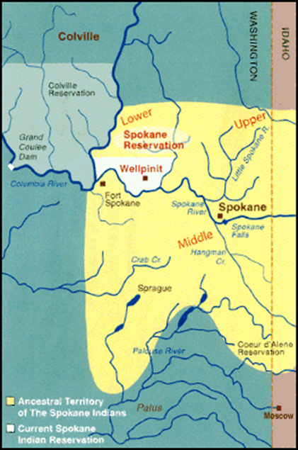 |


